GİRİŞ
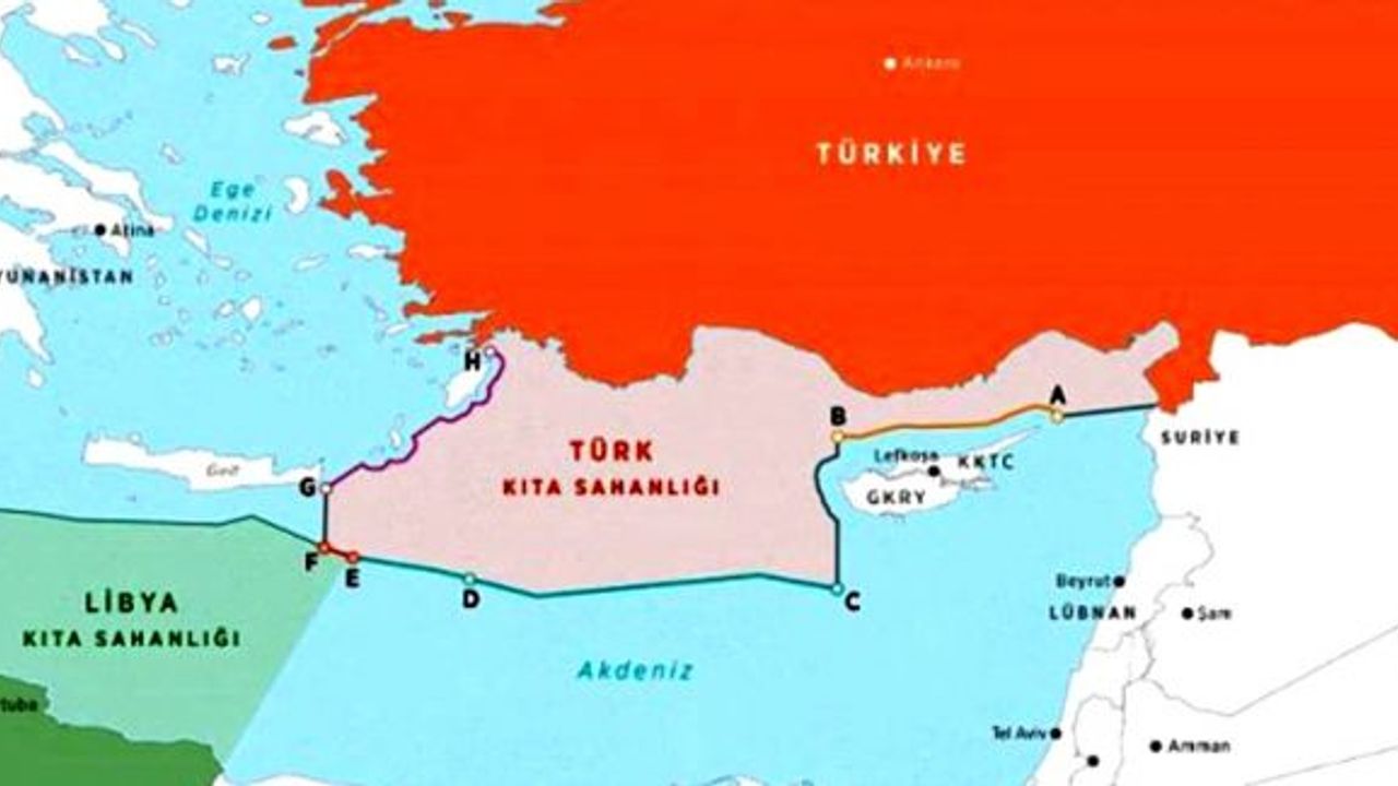
Söz konusu anlaşma ile Türkiye ve Libya’nın birbirlerine bakan anakaraları arasında deniz alanlarını belirleyen varsayımsal ortay hat belirlenmiştir. Belirlenen sınır 18 deniz mili (d.m.) uzunluğunda olup Mısır ile muhtemel sınırlara müdahale edilmemiştir.
Aşağıda Yunanistan, Güney Kıbrıs Rum Yönetimi (GKRY), Mısır ve İsrail arasındaki anlaşmalarda kabul edilen tezler hilafına Türkiye tarafından savunulan tezlerin ve sonucunda imzalanan bu anlaşmamanın hukuki temellerine yer verilecektir.
1. Türkiye’nin Kıta Sahanlığı
Türkiye ilk olarak 2004 yılında Akdeniz’deki kıta sahanlığımız konusunda Birleşmiş Milletlere (BM) bildirimde bulunmuştur. Son olarak 13 Kasım 2019 tarihinde de kıyımızdaki adaların kıta sahanlığını kesici bir etkisinin olmadığı, bu adaların karasularına kadarki alanların tamamının Türkiye’nin kıta sahanlığı kapsamında kaldığı bildirimi yapılmıştır.
Bu anlayış kapsamında ve Libya’nın Libya-Malta deniz alanları davasında Uluslararası Adalet Divanına sunduğu tezlerle uyumlu olarak iki ülkenin bir birine bakan yamaçları ile uyumlu olarak 18.6 deniz mili uzunluğunda kıta sahanlığını belirleyen ortay hat 27 Kasım 2019 tarihli metinle tespit edilmiştir.
Bu anlaşma bağlamında ele alınması gereken esas sorun adaların deniz alanlarına sahip olup olamayacağıdır. Adaların karasularına sahip olması hususu teamül hukuku iken (UAD, Katar-Bahreyn, 1992) diğer alanlar açısından bu söylenemez. Bu mesafenin de teamül hukuku olan kısmı 3 d.m. olup 12 d.m. anlaşmayla kabul edilmiştir. Fakat birçok devlet tarafından da uygulanmaktadır.
Türkiye ile Libya Devleti arasında imzalanan bu anlaşma uluslararası hukuk açısından Akdeniz deniz alanları paylaşımında Türkiye’nin duruşunu göstermektedir.
Öte yandan, GKRY’nin Türkiye tarafından tanınmaması nedeniyle Mısır (2007) ve İsrail (2011) ile yaptığı deniz alanları anlaşmalarının Türkiye yönünden hangi hukuki sonuçları olduğu da tartışmalıdır. Keza, GKRY’nin Lübnan ile 2007 yılında yaptığı anlaşma Lübnan parlamentosu tarafından onaylanmamıştır.
Bu arada Filistin Devletinin Gazze şeridi dolayısı ile Akdeniz ile sınırı olduğu ve henüz bir münhasır ekonomik bölge ilanı konusunda girişim yapmadığı kaydedilmektedir.
2. Konuya Dair Uluslararası Metinler ve Deniz Yetki Alanları
1958 tarihli Cenevre Sözleşmeleri ile 1982 tarihli Birleşmiş Milletler Deniz Hukuku Sözleşmesi konuya dair sözleşmelerdir.Cenevre Açık Denizler Sözleşmesini GKRY 1988 ve Cenevre Kıta Sahanlığı Sözleşmesini Kıbrıs 1974 tarihinde imzalamıştır.
Cenevre Deniz Hukuku Sözleşmesi, ve Cenevre Açık Denizlerde Balıkçılık ve Canlı Kaynakların Korunması Sözleşmesi ne Türkiye ne de GKRY tarafından imzalanmıştır. Öte yandan, Doğu Akdeniz havzasında bulunan devletlerden; 1958 Deniz Hukuku Sözleşmesini İsrail, 1982 BM Deniz Hukuku Sözleşmesini (UNCLOS) GKRY, Yunanistan, Mısır, ve Lübnan, 1958 Cenevre Karasuları ve Bitişik Bölgeler Sözleşmesini Yunanistan ve İsrail imzalamıştır. 1958 Cenevre Açık Denizlerde Balıkçılık ve Canlı Kaynakların Korunması Sözleşmesi ise bölge ülkeleri tarafından imzalanmamıştır.
Türkiye BM Deniz Hukuku Sözleşmesini imzalamamış ve GKRY’nin imzalaması üzerine deniz alanına dair haklarını engellemeyeceğini veya bu haklara etki etmeyeceğini belirtmiştir. Türkiye, bu anlamda var olan haklarını engelleyecek iddia ve girişimlere muvafakat etmediğini belirtmiştir. Ayrıca, diğer konularda bildirimde bulunma hakkını da saklı tutmuştur.
Diğer taraftan Libya, UNCLOS’u 1984 yılında imzalamış ancak onaylamamıştır. Dolayısıyla, hâlihazırda Sözleşmenin tarafı değildir.
Bu noktada aşağıda konuyla ilgili kavramların kısaca açılamasına yer verilmiştir.
2.a Münhasır Ekonomik Bölge
DM Deniz Hukuku Sözleşmesine göre karasuları iç sınırından 200 d.m. mesafesine kadar olan bölümdür ve ilanı gerektirir. Canlı ve cansız deniz dibi, üstü ve altı kaynakları araştırma ve işletme hakkı bahşeder.
2.b Kıta Sahanlığı
Kıta sahanlığı deniz altı kara parçası uzantısı olup karasuları dışında ancak açık denizler içerisinde olan alandır. Deniz dibinde ve altı toprakta araştırma ve işletme hakkı bahşeder. Her ülkenin ilan etmesine gerek olmaksızın ekonomik çıkarlarından istifade edebileceği bir kıta sahanlığı vardır. Ancak söz konusu alanın genişliği iki farklı şekilde hesaplanabilmektedir. Bunlardan hangisi genişse devlet onu kıta sahanlığı olarak belirleyebilir.
1982 tarihli Deniz Hukuk Sözleşmesine göre:
İlk olarak karasuları iç hattından itibaren ölçülecek 200 d.m. mesafe ve ikinci olarak karasının doğal uzunluğundan kıtanın sınırına (continental margin) kadar ulaşacak mesafe ki bu mesafe 200 d.m.nden kısa ise 200 d.m. esas alınacaktır. Bu hat 60 d.m.lik düz çizgilerle belirlenecektir.
Kıta sınırının daha uzun olması durumunda ise 350 d.m. yi aşamayacaktır ya da 2.500 metre derinlikten itibaren 100 d.m. ni aşamayacaktır.
200 d.m.ni aşan sınır belirlemeler ise Kıta Sahanlığı Sınırı Komisyonuna sunulacak ve Komisyonun tavsiyeleri doğrultusunda belirlenecektir. 13 Mayıs 2009 tarihi itibari ile bu tür talepler Komisyona iletilmiş olmalıydı.
1982 tarihli Deniz Hukuku Sözleşmesi bitişik ve karşılıklı kıyılara sahip devletler arasındaki kıta sahanlığının ve münhasır ekonomik bölgenin karşılıklı anlaşma ile yapılmasını öngörmektedir. Buna karşın kıta sahanlığı belirlenmiş ise bu sınır münhasır ekonomik bölge için de sınır kabul edilmektedir. Ancak bu sınırın kıta sahanlığı için belirlenecek daha geniş alan olması halinde bile 200 d.m. mili sınırını aşamaması gerekir.
2.c Müdahale Yetkisi
Deniz Hukuku Sözleşmesine göre bu alanlarda arama ve işletme faaliyetleri ilgili devletin iznine bağlıdır ve izin olmadan yapılan bu faaliyetlere müdahale edilebilir.Karasuları dışı esasen açık deniz kabul edilmektedir.
Karasularında egemenlikten söz edilirken karasuları dışındaki alanda egemen haklardan bahsedilmektedir. Yani karasularında zararsız geçiş kurallarına müdahale edilmeksizin ülke hukuku uygulanacaktır. Diğer alanlarda ise sadece bahşedilen bu haklar nedeniyle müdahalede bulunulabilecek bazı suçlar hariç diğer eylemler nedeniyle müdahalede bulunulamayacaktır.
Söz konusu alanlara egemenlik hakları kullanan devlet izni olmaksızın boru hatları döşenebilecektir.
2.d BM Deniz Hukuku Sözleşmesi ve Uluslararası Teamül Hukuku
BM Deniz Hukuku Sözleşmesi genel olarak uluslararası teamül hukukunun yazılmış hali olarak kabul edilmektedir. Ancak her bir madde bu anlamda ayrı ayrı incelenmelidir. Yani bu Sözleşmedeki tüm maddeler uluslararası teamül hukuku olmayıp bazıları sözleşme hukukudur. Bu kapsamda kıta sahanlığının durumu ayrıca incelenmelidir.
Öte yandan teamül hukuku daima bu teamül hukukuna itiraz etmiş (Persistent objector) olan devlete karşı bu teamül hukuku uygulanmaz. Türkiye’nin BM Deniz Hukuku Sözleşmesini imzalamamış olması ve bu anlamdaki bildirimi ile BM Kıta Sahanlığı Sözleşmesini imzalamamış olması bu şekilde değerlendirilebilir. Yine 2003 yılında GKRY-Mısır arasında yapılan münhasır ekonomik bölge anlaşmasına da Türkiye itirazını belirtmiştir.
2.e Adaların deniz yetki alanları
Ada gelgit zamanlarında dahi su üzerinde kalabilen doğal toprak alanlarıdır. Eğer bir kara parçası bu statüye sahipse bu adanın karasuyu, bitişik bölge, kıta sahanlığı ve münhasır ekonomik bölge hakları olacaktır. Ancak bu haklar anakara devletleri karşısında onların sahip olduğu haklar kadar olmamalıdır.
Öte yandan insan yaşamının sürdürülemediği yada kendi ekonomik yaşamını sürdüremeyen kayalık alanlar ekonomik bölge ve kıta sahanlığı haklarına sahip olamaz.
3. Konunun Önemi ve Konuya Dair Yargısal Kararlar
Söz konusu anlaşma Doğu Akdeniz’de yer alan tartışmalı bölgelerdeki sondaj parsel alanlarının belirlenmesi, yer altı kaynaklarının araştırılması ve işletilmesi açısından önemlidir.
Ayrıca bu anlaşma ada devleti veya adaya sahip devletlerin UNCLOS’un da tanıdığı deniz yetki alanına tam olarak sahip olmayacağı konusunda anlayışın ortaya çıkması açısından da değerlidir. Anlaşma ile bölgesel anlamda bir yaklaşım gösterilmiş ve diğer devletlerin yaptığı anlaşmaların bölgesel teamül durumuna gelmesi önlenmiştir.
Öte yandan, Türkiye’nin adaların karasuları hariç deniz yetki alanları olmadığına dair tezinin bir başka devlet tarafından da desteklenmiş olması diğer devletlerin yaklaşımlarını da değiştirebilecektir.Nitekim, Türkiye’nin tezleri hukuki temellere de sahiptir. Buna dair uluslar arası düzeyde verilmiş kararlar da mevcuttur.
3.a Katar Bahreyn Arasında Toprak ve Denizalanı Sınırı Davası (UAD, Katar- Bahreyn, 2001)
Divan, her iki devletinde Cenevre Deniz Hukuku Sözleşmesine taraf olmadığını, Birleşmiş Milletler Deniz Hukuku Sözleşmesine ise sadece Bahreyn’in taraf olduğunu Katar’ın ise Sözleşmeyi sadece imzaladığını belirterek anlaşmazlığı Deniz Gelenek Hukukunun uygulanacağını belirmiştir.
Divan, davada düz esas sınır çizme şartlarından da bahsederek Bahreyn’in saçak adalara sahip olacak derecede çok adasının olmadığını, sınırının çok girintili olmadığını belirterek düz esas çizgi ile karasularını belirleyemeyeceğini belirtmiştir. Öte yandan Bahreyn’in kendisini takımada olarak ilan etmediğini de tespit edilerek takımada esas çizgisinin de uygulanamayacağını belirterek tüm adaların kendi etkisi tahtında sınır belirlemesi yapılabileceğini belirtmiştir.
Divan kararında önemsiz derecede olan oluşumlara orantısız bir hak bahşetmenin uygun olmayacağına vurgu yapmıştır. Öte yandan Katar’ın bir kısım sularına erişimi ancak Bahreyn sınırları içinde kalan sulardan olacağından adalar arası düz esas çizgi de çizilemediğinde bu adalar arası suların iç su olmadığına ancak Bahreyn’in karasuyu olduğuna hükmederek her iki tarafın da birbirlerinin karasularından zararsız geçiş hakkına sahip olduğuna vurgu yapmıştır.
Divan, hakkaniyetli sonuç elde etmek için orta hattın belirlenmesi ya da kaydırılması faktörlerini incelemesi gerektiğini, bu bağlamda “ilgili şartlar” konseptinin genel gelenek hukuku olduğunu ve bölüşüm sırasında göz önüne alınması gerektiğini belirtmiştir.
Divan ayrıca Bahreyn karasularında kalan Fasht Al Jarim adacığının gelgit alt sınırının esas hat olacağını belirtmişse de bu adacığı deniz alanları bölüşümünde tam etki verilmesinin sınırın yönünü değiştireceğini ve orantısız bir etki yapacağını belirterek gelgit sırasında oldukça az bir bölümünün su yüzeyinde kalabildiğini de dikkate alarak denizalanı bahşetmede hiçbir etki doğurmayacağına karar vermiştir.
3.b Kanada-Fransa Deniz yetki alanları belirlemesi (Arabuluculuk Mahkemesi, 1992)
Mahkeme tarafların ileri sürdüğü vatandaşlarının ekonomik hayatının balıkçılığa bağlı olduğu argümanını bölüşüm sırasında dikkate alamayacağını, zira bölüşümün coğrafi olduğunu, buna karşın radikal bir şekilde bölüşümün adil olmaması durumunun dikkat edilmesi gereken bir faktör olduğunu, UAD’ın Kanada-ABD arasında görülen Maine Körfezi davasında “radikal şekilde adaletsiz” liği geçim ve ekonomik gelişmeye katostrafik bir etki doğurma ihtimali olarak tarif ettiğini belirtmiştir.
Mahkeme, neticeten buradaki Fransız adalarına UNCLOS’ta öngörülen deniz alanlarının tamamını değil oldukça küçük bir alanı belirlemiştir. Ayrıca balıkçılık durumunun anlaşmalar dolayısı ile bu alan belirlemesinden etkilenmeyeceğini not etmiştir.
3.c Büyük Britanya-Fransa Kıta Sahanlığının Belirlenmesiyle ilgili Dava (Arabuluculuk Mahkemesi, 1977)
Mahkeme İngiliz Kanalı içinde yer alan “Isle of Wight”in ana karadan dar bir geçitle ayrıldığını ve neredeyse bitişik olduğunu, “The Scilly Isles”ın anakaraya 21 d.m. mesafede olduğunu, bazılarında yaşam olan 48 adadan oluşan ve ana kararanın doğal coğrafi uzantısı niteliğinde olduğunu, anakarayla arasında gelgit’lerde su altında kalan kayalıklar olduğunu, kanal içersinde 8 d.m. mesafedeki bir kayalık üzerinde Büyük Biritanya’ya ait deniz feneri bulunduğunu belirtmiştir. Avrupa yakasına yakın olan Breton-Normand Körfezinde Büyük Biritanya’ya bağlı Alderney adalar grubu-Avrupa kıyısına sekin deniz mili ve anakaraya 49 d.m., Guernsay adalar grubu-Avrupa kıyısına en uzak olan, Jer-sey adalar grubu-Normandiya kıyısına 6.6 d.m. mesafede, Minquires adalar grubu-Jersey adasına 16 d.m. ve Fransa’ya ait “Iles Chausey” adalarına 8 d.m. takımada grupları olduğunu belirmiştir. Bu adaların bir kısmında yaşam olup bazıları kayalıktır ve toplam yüzölçümleri 195 kilometrekaredir. Öte yandan, kanalın çıkışında Fransa’ya ait anakaraya 14 d.m. mesafede adacık, kayalık ve kumullardan oluşan Ushant adaları vardır.
Fransa tüm sınırları için 12 d.m. karasuyu ilan etmişse de Büyük Britanya bu hakkı saklı olmakla birlikte şimdilik Kanal içerisinde 3 d.m. karasuyu ve 12 d.m. balıkçılık alanı ilan ettiğini belirmiştir.
Mahkeme değerlendirmelerden sonra olaya 1958 Cenevre Kıta Sahanlığı Sözleşmesinin uygulanacağını ve uluslararası teamül hukukundaki gelişmelerin de göz önüne alınacağını belirtmiştir. Uluslararası teamül hukukunun temel prensipleri arasında “orantılılık” ve “doğal oluşumların etkisinin makul değerlendirmesi” ilkelerinin bulunduğunu, orantılılık ilkesinin bu davada uygulamak için geniş olduğunu ve oluşumların etkinin değerlendirilmesinde bir faktör olabileceğini belirtmiştir. Karşılıklı devletlerin kıta sahanlıklarının o devlet anakarasının uzantısını yansıttığını vurgulamıştır. Orantılılık ise bu belirmenin ve diğer oluşumların etkisiyle ortaya çıkacak belirlemelerin kıyı/kıta sahanlığı oranı açısından hakkaniyetli olup olmadığını tespitte bir faktördür.
Mahkeme karşılıklı iki devlet arasındaki ortay hat çizmeyi yetkisi içinde görmüş ve Breton-Normand Körfezi içindeki sığ sularda kıta sahanlığı çizme yetkisi verilmediğini belirtmiş ise de buradaki adaların nasıl değerlendirileceği hususunda görüş ayrılığı mevcut idi. Büyük Britanya adarların olduğu yerden itibaren karşılıklı iki kıyı arasında ortay hat önerirken Fransa anakaralar arasında ortay hattın olacağını, körfez içindeki adaların ise Fransa kıta sahanlığı içerisindeki ayrı alanlar olarak değerlendirilmesi gerektiğini belirtmekteydi. 1958 Cenevre Kıta Sahanlığı Sözleşmesinin 6’ncı maddesindeki çekince ve karşı beyanları göz önüne alan Mahkeme uygulanacak kuralın uluslararası teamül hukuku olduğuna karar vermiştir. Mahkeme, adaların İngiliz Kanalının içinin bir parçası olduğunu,anakaralar arasındaki ortay hattın her iki tarafa da hakkaniyet ölçüsünde kıta sahanlığı bıraktığını ve bu adalar olmasaydı bölüşümün bu şekilde olacağını, adaların körfezin kolları arasında olup coğrafi şartları bu nedenle bozduğunu belirtmiştir.
Mahkemeye göre anakaranın doğal uzantısı olan kıta sahanlığı konsepti ne kenara atılabilir ne de başka devletin kıta sahanlığı içinde yer alan adalar için mutlaktır. Böyle bir durumda adalara deniz alanları oluşturmakta tam etki verilirse anakara devleti yönünden diğer halde kendisinin olacak olan kıta sahanlığından belirgin bir azalma olacaktır ki bu hakkaniyete aykırıdır. Bu da adil ve hakkaniyetli olması gereken bölümlemenin adaletsizlik şartlarıdır ve özel şartlar konsepti altında değerlendirilmelidir.
Bu değerlendirmelerden sonra Mahkeme, Kanal içerisinde ortay hat ile kıta sahanlığının belirlenmesine, Körfez içerisindeki adaların 12 d.m. balıkçılık sahası dışındaki alanların Fransa kıta sahanlığı olduğuna-Fransa yönündeki iç sığ kısımları yetkisi dışında görmüştür karar vermiştir.
SONUÇ
Libya ve Türkiye kıta sahanlığı ve münhasır ekonomik bölge sözleşmelerine taraf olmamaları nedeniyle sözleşmesel olarak bir yükümlülük altında değildir.
Adaların karasularına sahip olduğu hususu uluslararası deniz teamül hukukudur. Bir kısım devletlerce uygulanmaya başlanan 12 d.m.lik karasuyu sınırı UNCLOS ile tanınmış olup bu uygulama Akdeniz bölgesinde tam olarak kabul görmemiştir.
Kıta sahanlığı ve münhasır ekonomik bölge, sözleşmelerde yer verilmiştir ve bir kısım ülkeler tarafından da uygulanmaktadır. Sınır veya karşılıklı olan devletlerle ortay hat çizilmesi hususu ikili anlaşmalara bağlıdır.
Öte yandan adaların, anakara ile eşdeğer kıta sahanlığına ve münhasır ekonomik bölgeye sahip olmadıkları mahkeme kararları ile sabittir. Belirlemede özel şartlar, adaların durumu, ilgili alanlar ile ilgili kıyıların uzunluğu gibi birçok faktör devreye girmektedir. Yine bu durumda adaların karasularının ana karaya çok yakın olan yerlerde örnek mahkeme kararlarında uygulanabildiği gibi 3 d.m. altına da düşecek şekilde ve en fazla 3 d.m. ile sınırlanması anakaraların deniz üzerindeki hakları açısından önem arz etmektedir.
Ayrıca, adaların deniz alanları hakları değerlendirmesinde, Ege’deki adaların Türkiye anakarasının uzantıları durumunda olduğu ve Türkiye anakarasını bir set halinde kesmemekte oluşları da göz önüne alınarak yukarıdaki kararlar ışığında deniz alanlarına ya hiç ya da oldukça az sahip olmaları gerektiği değerlendirilmelidir. Bu anlamda başka devlet anakarasına yakın ve onların coğrafi olarak uzantısı olan adaların 3 d.m. karasuyu hariç, anakaraya bakan yönleri daha az olacak şekilde, deniz alanlarına sahip olmamaları, yukarıdaki içtihatlarla uyumlu olacaktır.
Diğer taraftan, Yunanistan’ın Ege adalarını takımada olarak niteleme çabaları takip edilmelidir. Esasen takımada tabiri UNCLOS’ta anakarası olmayan ada devletler için öngörülmüştür. Fakat bir kısım devletlerin takımada suyu ilan ettikleri de bilinmektedir. Türkiye’nin bunlara karşı şimdiden rezervlerini ilgili kuruluşlara sunmasının faydalı olabileceği akla gelmektedir.
Selahattin DOĞAN
Daire Başkanı
---
A LEGAL EVALUATION OF TURKEY-LIBYA MARITIME BOUNDARY AGREEMENT
INTRODUCTION
Amemorandum of understanding on maritime boundaries was signed between the Republic of Turkey and Libya on 27 November 2019. The memorandum of understanding then went through the approval processes of the Grand National Assembly of Turkey (GNAT) and the Presidency, and was published on the Official Gazette on 07 December 2019 and was put into effect on 08 December 2019.
With this agreement, a presumptive median line identifying the maritime areas between the opposing mainland territories of Turkey and Libya was drawn. The border’s length determined is 18 nautical miles (NM) and this border does not interfere with the possible borders with Egypt. The following sections will include the legal basis defended by Turkey in contrary to the agreements signed between Greece, Greek Administration of Southern Cyprus (GASC), Egypt and Israel.
1. The Continental Shelf of Turkey
Turkey made the first notification to the United Nations (UN) on our continental shelf in the Mediterranean Sea in 2004. Lastly, it was notified on 13 November 2019 that the islands on our coasts did not have an intersecting effect on the continental shelf and that all of the areas up to the territorial waters of these islands was under the continental shelf of Turkey.
Within the scope of this understanding and in line with the thesis asserted by Libya to the International Court of Justice (UC) on the case concerning the maritime areas between Libya and Malta, a median line of 18.6 nautical miles was created between two countries with the text of 27 November 2019, which identifies the continental shelf in accordance with the opposing sides of the two countries.
The main issue that needs to be addressed in the context of this agreement is whether the islands could have maritime areas or not. Although the issue of islands’ having continental shelves is under the customary law (ICJ, Qatar-Bahrain, 1992), this cannot be stated for other areas. 3 NM of the distance in question is under the customary law and 12 NM was accepted with the agreement, and this is implemented by many States.
This agreement signed between Turkey and the State of Libya demonstrates Turkey’s stance concerning the sharing of maritime areas in the Mediterranean Sea from the aspect of international law.
On the other hand, legal consequences. By the GASC of agreements of maritime areas signed with Egypt (2007) and Israel (2011) is controversial on Turkey’s part since Turkey does not recognise the GASC. In a similar vein, the agreement between the GASC and Lebanon signed in 2007 was not approved by the parliament of Lebanon.
At the same time, it is noted that the State of Palestine has a boundary to the Mediterranean Sea due to the Gaza strip and that there are no initiatives to proclaim an exclusive economic zone.
2. International Texts Regarding the Issue and Maritime Jurisdiction.
Geneva Conventions of 1958 and the United Nations Convention on the Law of the Sea of 1982 are the conventions regarding the issue.
The GASC signed the Geneva Convention on the High Seas in 1988 and Cyprus signed the Geneva Convention on the Continental Shelf in 1974. Neither Turkey nor the GASC signed the Geneva Convention on the Law of the Sea and the Geneva Convention on Fishing and Conservation of the Living Resources of the High Seas. On the other hand, among the States of the Eastern Mediterranean basin, Israel signed the 1958 Convention on the Law of the Sea, the GASC, Greece, Egypt and Lebanon signed the 1982 UN Convention on the Law of the Sea (UNCLOS), and Greece and Israel signed the 1958 Convention on the Territorial Sea and Contiguous Zone. The Geneva Convention of 1958 on Fishing and Conservation of the Living Resources of the High Seas was not signed by the countries of the region.
Turkey did not sign the UN Convention on the Law of the Sea and, upon the signing of the GASC, it stated that it would not hinder its rights on maritime areas or have an impact on these rights. Turkey stated that it did not consent to claims and initiatives that would hinder its existing rights within this meaning. In addition, it reserved the right to make notifications on other issues.
On the other hand, Libya signed the UNCLOS in 1984 but it did not ratify the Convention. Therefore, it is currently not a party to the Convention.
At this point, brief explanations of the concepts regarding the issue are provided below.
2.a Exclusive Economic Zone
In accordance with the UN Convention on the Law of the Sea, it is the zone from the internal boundaries of territorial waters up to 200 NM and requires proclamation. It bestows the right to explore and exploit living and non-living resources of the waters superjacent to the seabed and of the seabed and its subsoil.
2.b Continental Shelf
The continental shelf is the submarine prolongation of the land and is beyond the territorial waters but at the high seas. It bestows the right to explore and exploit the seabed and its subsoil. Every country has its own continental shelf whose economic interests can be exploited by that country without the need for any proclamation. However, the breadth of the area in question can be calculated in two different ways. The State will select the widest one as its continental shelf.
In accordance with the Convention on the Law of the Sea of 1982:
First, 200 NM from the baseline of the territorial waters and secondly, the distances from the natural prolongation of its land territory up to the continental margin, which, if shorter than 200 NM, will be accepted as 200 NM. This line will be determined with straight lines of 60 NM.
If the continental margin is longer, it cannot be more than 350 NM or 100 NM from the depth of 2.500 meters.
Determination of boundaries which are longer than 200 NM shall be communicated to the Commission on the Limits of the Continental Shelf and the continental shelf will be determined in line with the recommendations of the commission. Such demands should have been communicated to the Commission as of 13 May 2009.
Convention on the Law of the Sea of 1982 provides for that the continental shelf and exclusive economic zone between states with opposite and adjacent coasts are determined with a mutual agreement. However, if the continental shelf is determined, then this limit is also accepted for the limit of the exclusive economic zone. Nonetheless, even if there is a wider area for being determined of the continental shelf, this limit should not exceed 200 NM.
2.c Power of Interference
In accordance with the Convention on the Law of the Sea, exploring and exploiting activities in these areas are subject to the permission of the relevant State and the acts carried out without permission can be interfered with.
The area beyond the territorial waters is essentially accepted as the high seas. While sovereignty exercises on the territorial waters, States have sovereign rights on the areas other than the territorial waters. In other words, the law of the State inquestion will be implemented on the territorial waters without interference with the innocent passage rules. In other areas, an interference will be possible for the acts breaching these bestowed rights, and an interference will not be possible due to the other acts except certain crimes.
Pipelines can be laid in the areas in question without the permission of the State enjoying the sovereign rights.
2.d The UN Convention on the Law of the Sea and Customary International Law
The UN Convention on the Law of the Sea is generally accepted as the written form of the customary international law. However, each article should be examined separately within this meaning. Namely, all the articles in this Convention are not the customary international law and are under the law of contracts. Within this scope, the situation of the continental shelf should be examined separately.
On the other hand, even if a customary law formed, this customary law cannot be implemented for the State that is persistent objector. The fact that Turkey did not sign the UN Convention on the Law of the Sea and its notification within this scope and the fact that it did not sign the UN Convention on the Continental Shelf can be evaluated within this scope. Similarly, Turkey raised an objection to the exclusive economic zone agreement between the GASC and Egypt in 2003.
2.e Maritime Jurisdiction of Islands
Islands are naturally formed areas of land which can stay above water even at the high tide. If a part of land has this status, it will have the rights of territorial waters, the contiguous zone, the continental shelf and the exclusive economic zone. However, in comparison with continental state, these rights should not be as much as the rights enjoyed by the continental.
On the other hand, rocks which cannot sustain human habitation or economic life of their own cannot have an exclusive economic zone and continental shelf.
3. The Importance of the Issue and Judgments on the Issue
The agreement in question is important for the identification of drilling parcel areas in controversial regions of the Eastern Mediterranean, and exploration and exploitation of underground resources.
In addition, this agreement is also valuable in that it reveals the understanding that the island States or States having islands cannot have full maritime entitlement, which is also granted by the UNCLOS. The agreement embraces a regional approach and it prevents the agreements of other States from becoming regional customary law.
Moreover, the fact that the thesis Turkey assert that islands do not have maritime jurisdiction other than the territorial waters is supported by another State might alter the aproaches of the other States.
In fact, theses of Turkey have legal basis. There are also international judgments regarding this matter.
3.a Case Concerning Maritime Delimitation and Territorial Questions between Qatar and Bahrain (ICJ, Qatar- Bahrain, 2001)
The Court ruled that Maritime Customary International Law of the Sea was applicable to the casaunderlining that neither Qatar nor Bahrain was a party to the Geneva Convention on the Law of the Sea and only Bahrain is a party to the UN Convention on the Law of the Sea but Qatar is only a signatory to it.
The Court stated that Bahrain could not apply the method of straight baselines in order to determine its territorial waters emphasising that its coasts were not indented and did not have an adequate number of islands to qualify them as a fringe of islands. On the other hand, the Court ruled that each island had its own effect for the determination of the baselines mentioning that Bahrain had not declared itself as an archipelagic state; thus, it could not apply the archipelagic baselines.
In its judgment, the Court underlined that it would be disproportionate to bestow rights to insignificant maritime features. Furthermore, the Court emphasised that both parties shall have the right to innocent passage in the territorial waters of the other party as Qatar could only reach some of its waters through the waters located in the Bahrain boundaries and straight lines could not be drawn between the islands ruling that waters between these islands were not internal waters but the territorial waters of Bahrain.
The Court stated that other factors which might suggest an adjustment or shifting of the median line in order to achieve an equitable result should be examined and concluded that the concept of “relevant circumstances” was the general customary law and it should be applied during the delimitation process.
Even if the Court stated that the law tide line of the islet of Fasht Al Jarim, which is located on the territorial waters of Bahrain, would be the baseline, it ruled that giving a full effect to this islet in the delimitation of maritime areas would distort the boundary and have a disproportionate effect, and concluded that it would have no effect in determining the boundary in the maritime delimitation given that a minute part of it was above water at high tide.
3.b Delimitation of the Maritime Areas between Canada and France (Court of Arbitration, 1992)
The Court stated that it would not consider, during the delimitation process, the argument that the economic lives of the individuals depend on the fishery, asserted by both of the parties, since the delimitation process is geographical; however, radically inequitable delimitation was a factor to be taken into consideration which is not fair and stated that the ICJ described “radical inequity” as having a possible catastrophic impact on the livelihood and economic development in the case of Gulf of Maine between Canada and the USA.
In conclusion, the Court aranted a small part of maritime entitlement for French islands at this area, not the whole of the maritime entitlement provided for in the UNCLOS. In addition, it noted that fishery would not be affected from this delimitation process due to the agreements.
3.c Case Concerning Delimitation of the Continental Shelf between Great Britain and France (Court of Arbitration, 1977)
The Court stated that “the Isle of Wight”, located in the English Channel, is divided from the mainland only by narrow passages and it may be said to be comprised within the coastline of the mainland itself. The Court further stated that “the Scilly Isles” have a distance of 21 NM to the mainland and it consists of 48 islands some of which are inhabited, and it is geographically a natural prolongation of the mainland. The Court added that there are also rocks which submerge at high tide and there is a lighthouse upon the rocks belonging to Great Britain which lies 8 NM to the channel. It further stated that there are groups of archipelagos: the Alderney group of islands of Great Britain located in the Gulf of Breton-Normand, which is close to the European side, lies eight nautical miles to the European coast and 49 NM to the mainland; the Guernsey group of islands is situated furthest from the European coast; the Jersey group of islands lies 6.6 NM to the Normandy coast; the Minquires group of islands lies 16 NM to the island of Jersey and 8 NM to “Iles Chausey”, belonging to France. Some of these islands are inhabited and some of them are rocky and their total surface area is 195 square kilometres. On the other hand, there are the Ushant islands, belonging to France, that lies 14 NM to the mainland at the exit of the channel, which consists of rocks, shoals and islets.
Even if France established 12-NM territorial waters for all of its boundaries, Great Britain reserves this right and it established 3 NM of territorial waters and 12 NM of fishery zone inside the Channel.
After the considerations, the Court held that the Geneva Convention of 1958 on the Continental Shelf was applicable and that the developments in the customary international law would also be taken into consideration. It stated that “proportionality” and “reasonable evolution of the effects of natural features” were among the fundamental principles of the customary international law and that the principle of proportionality was too wide to be applicable in this case and it could be a factor in the evaluation of the effects of features. It emphasised that the continental shelf of the opposite States reflects the prolongation of the mainland of that State. Proportionality, on the other hand, is a factor in the determination of the equitable nature of the proportion of this determination and determinations that will be obtained with the effect of the other features to the coast/continental shelf.
Even if the Court saw drawing median lines between two opposite countries under its jurisdiction and stated that it did not have the authority to draw a continental shelf on the narrow waters in the Gulf of BretonNormand, there was a difference of opinion on how to consider these islands. While Great Britain suggested a median line between two opposite coasts from the location where the islands are located, France sustained that the median line should be between the continental territories and the islands inside the gulf should be evaluated as separate areas under the continental shelf of France. Considering the reservation under Article 6 of the Geneva Convention of 1958 on the Continental Shelf and the statements of the opposing parties, the Court held that the rule to be applied was the customary international law.
The court held that the islands were an integral part of the English Channel, that the median line between the mainland territories left an equitable continental shelf to both of the parties, and that the delimitation would be as such if there had not been islands, and that the islands were located on the arms of the gulf and thus disturbed the geographical conditions.
In the opinion of the Court, the concept of the continental shelf, which is the natural prolongation of continent, is neither to be set aside nor treated as absolute in a case where islands belonging to on the State. If islands were given full effect in delimiting maritime areas, there would be a substantial diminution in the continental shelf of the continental State which would otherwise accrue to itself, and this situation is to be inequitable. These are the unfairness conditions of the delimitation, which should be justified and equitable, and this should be evaluated under the concept of special circumstances.
After these considerations, the Court concluded that the continental shelf was determined with the median line in the Channel and that the areas 12 NM beyond the fishery zone of the islands located inside the gulf were the continental shelf of France - it deemed internal shallow areas on the side of France out of its jurisdiction.
CONCLUSION
Libya and Turkey have no contractual obligations since they are not a party to the conventions of the continental shelf and exclusive economic zone.
The fact that islands have territorial waters is under the customary international law of the sea. A limit of 12 NM for the territorial waters, which has been started to be implemented by some States, is recognised with the UNCLOS but this implementation is not fully accepted in the Mediterranean region.
Continental shelf and exclusive economic zone have been included in the conventions and some of the States are implementing them. Limits or drawing of median lines for opposing States depends upon the bilateral agreements.
On the other hand, it is established with the court decisions that the islands do not have an equal continental shelf and exclusive economic zone as with the continental territories. There are many factors in the determination processes such as special circumstances, the situation of the islands, length of the coasts of the relevant areas and etc. In a similar vein, it is also important, for the rights of the continental territories on the seas, those ample court decisions might be implemented where territorial waters of islands are too close to the continental, or the territorial waters of islands might be limited up to 3 NM or below 3 NM.
In addition, in the evaluation of the rights of maritime areas of the islands, it should be considered, in light of the above-mentioned judgments, that the islands on the Aegean Sea should have no or just a little maritime area given that they are the prolongation of the mainland of Turkey and they do not cut the mainland of Turkey as a barrier. It will be in line with the case law mentioned above that islands, which are close to the continent of other States and prolongation of them, should not have maritime areas except for the 3 NM territorial waters, in a manner where their sides opposing the continental states have a smaller area.
Moreover, the efforts of Greece to named that the Aegean islands are archipelagos should be followed. Essentially, the expression of archipelago is provided in the UNCLOS for island States that do not have mainland territories. However, it is also known that few states have announced archipelagic waters. This leads us to think that it might be useful that Turkey submits declarations to the relevant organisations against them from now.
Selahattin DOĞAN
Head of Department
* Uluslararası Hukuk Bülteni'nin 19. Sayısından Alınmıştır.